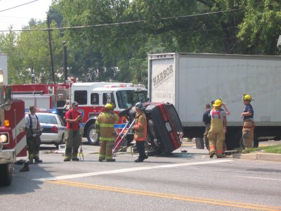
This intersection has been a problem for many years, but with the recent significant increase in traffic, it has become especially dangerous, as well as frustrating when the traffic backs up.
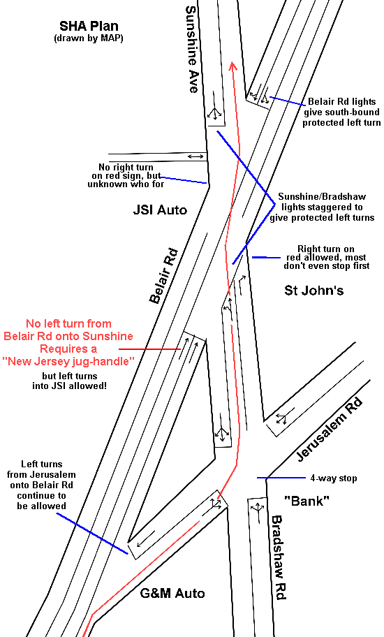
The State Highway Administration developed a plan to prohibit left turns for north-bound traffic from Belair Rd onto Sunshine Ave, and instead require a "New Jersey jug-handle" type turn, that is, requiring that traffic first turn right onto Jerusalem Road and then left onto Bradshaw. An extra lane was added to Bradshaw Rd to accommodate traffic turning left onto south-bound Belair Rd, and there were changes to the traffic signals in order to provide protected left turns for traffic in the other three directions.
On May 24, 2006, the new traffic pattern was put into effect. There remained other problems such as the mis-aligned signs on the traffic crossarms which can be seen by drivers from the wrong direction. Drivers are still regularly seen turning left onto Sunshine. And left turns from north-bound Belair Rd into JSI are, for same strange reason, still allowed!
The situation was further confused when SHA removed two signs from westbound Bradshaw which tell drivers which lanes to use and a sign which prohibited right turns on red. The remaining steady red right-turn arrow was confusing, since the national standard (adopted by Maryland) says that this signal means that no right turn on red is allowed, in contradiction to a sign which was put up (in the wrong place) saying that right turns on red were allowed. That sign then disappeared and the red light was changed to a flashing red arrow. The national guidelines state that any intersection with less/greater than a 75/105 degree angle should not be right-turn-on-red. This intersection is 26/154 degrees.
The initial accident reports indicate no improvement. During June-August 2005 there were 6 reported crashes and the same number during the same time period in 2006 after the change was put into effect. There were fatalities near this intersection in both 2006 and 2008. This should continue to be monitored. It is unknown what SHA's threshold of deaths is before they will do something! Anyone want to volunteer to add to the statistics?
Later, SHA installed a "No Right Turn on Red" at the corner of Sunshine and Belair Rd (in front of JSI), but it is unclear which roadway it is intended for since it can be seen equally by drivers on both Sunshine and Belair.
Detailed signal plan.
Because of continuing questions regarding the mistakes made in the original signage, SHA has planned a new project, originally to be done in Fall 2015 (obviously wasn't), to redo some of this signage. In addition, because of citizen complaints, the timing of the lights was adjusted to give traffic on Belair Rd additional time. However, this has caused a noticable increase in the backups on Bradshaw Rd, which then causes worse backups onto Belair Rd by traffic existing onto Jerusalem Rd. There is no workable correction with the current intersection configuration!
The problem is made much worse by the continued left turns in and out of JSI and, worse yet, drivers backing out of their parking lot onto busy Belair Rd. The approved site plan from 1991 was to prevent this dangerous backing and the excessive parking in the front. That site plan has not been followed.
This whole area was opened as a CZMP 2016 issue by Councilman Marks. The result provides some downzoning to prevent any thought of putting in a large box store here. But a large gas station would be allowed!
Current traffic situation
What was really bizarre and impossible to understand was that the County continued to rate this intersection as "A", with studies being done on 8/12/2014 and 8/17/2014 ("current" and "previous" studies respectively, according to the official report). Note that both these studies were supposedly done when school was not in session. Locals are all aware of the serious back-ups that occur here many times, which should cause a failing rating. The problem is that those doing the study believe that they should only consider cars that have already gotten through the 4-way stop at Jerusalem. Therefore, they don't even consider all the vehicles lined up at thie 4-way stop waiting on Bradshaw, Jerusalem, and sometimes even on north-bound Belair. In 2019, the rating was finally changed to "C".
|
Click here for an Alternate proposed plan
The next step!
In December 2016, we were notified that the state and county were discussing a complete redo of this intersection. The initial plan was to bring both Bradshaw and Sunshine out to nearly perpendicular intersections at Belair, with Bradshaw going through the Triangle and Sunshine through the vacant church property. There would then be a 400 ft jog between Bradshaw and Sunshine. This plan would require careful examination to determine if it would actually make the situation better. A quick examination of the area indicates that an offset of at least 700 ft would be required to allow both roads to come out at a right angle onto Belair Rd.
Incidentally, this sort of idea was opposed before based on a claim that the vacant church property is "historic", so cannot be disturbed. While it is true that this parcel is listed in the Maryland Historic Trust "Inventory" as BA-132, this by itself does not confer "historic" status or prevent use.
In fact, the data appears to show that it was mis-identified and entered into the Inventory incorrectly. While the first page of the nomination form filled out in 2003 lists it as applying to Tax ID 1119000750 and parcel 55:329 (which is the parcel with the church and cemetery), a later page says Tax ID 1119000751 and Parcel 55:219, which is the parcel on the northwest corner of Belair/Sunshine through which the road would go, and the vacant lot used as a parking lot to the north of the church property which the church acquired in 1959. But that page also mistakenly says it is in Hydes and lists the deed reference as 527:310, which is only a part of this parcel and the 3 parcels north of it. All of the descriptions and photos in the nomination form are of the church and cemetery, not any vacant lot. For more confusion and mistakes, the from later says "Since its construction in 1817, St John's Episcopal Church has been associated with the 1.3 acres of land known as tax parcel 291 of map 55." According to the forms, the "determination of eligibility" was filled out by Anne Bruder on 17 Oct 2003 but the actual inventory form was prepared on 29 May 2001.
Some years ago, a map of "historic properties" showed this one as being the vacant lot next to Sunshine. That was clearly a mistake.
The area is also a part of the potential Kingsville Historic District listed on the Inventory as BA-3130, which, incidentally, correctly identifies the Church (BA-132) as Map 55, Parcel 329. When this form was done in Dec 2003, the preparer (SHA) determined that the area was not eligible for "Historic" designation (partly noting that the house at 11819, mis-identifed as 11825, was "surrounded by a gravel parking lot and used cars". Looking at the photos, it is obvious why it was not recommended and who was responsible.
New plan
|